
12
Starlink Mobile’s real constraint might not be satellite coverage but capacity per square kilometer. A new model, offered up by Vish Nandlall, suggests where population density forces satellite service back toward terrestrial sites, backhaul, and conventional mobile infrastructure. The base case can carry a 10% mobile share across most populated US land, he says; the economics change sharply once population density moves above roughly 80 people per km².
John Stankey and Elon Musk are making competing claims about Starlink Mobile. Stankey says the small terrestrial radios SpaceX would need will cost as much as a conventional mobile network. Musk says the satellite system can eventually offer better coverage and higher bandwidth than cellular. Both claims become easier to judge if the network is reduced to one square kilometre during the busy hour. I decided to math this out.
A mobile network has to put enough capacity where people are. Satellites are very good at spreading a signal across land. They are much less able to move that capacity toward a crowded suburb or city block. In the base case I modelled, a next-generation Starlink beam can carry the outdoor busy-hour traffic of a 10% mobile share until population density reaches about 82 people per km². That number gives the debate a boundary.
I use a 40 m² antenna array at about 330 km altitude, 25 MHz of downlink spectrum and spectral efficiency of 1 bit per second per hertz. That gives the beam about 25 Mbps. Spread across a beam roughly 9.3 km wide, capacity is about 0.33 Mbps per km².
A subscriber using 20 GB a month puts about 0.10 Mbps on the network during the busiest hour under the traffic profile in the model. I assume 40% of cellular traffic happens outdoors or in vehicles, where the satellite link is useful. The satellite therefore sees about 0.04 Mbps of busy-hour demand for each subscriber. Divide 0.33 by 0.04 and the beam supports about eight subscribers per km². At a 10% market share, that corresponds to a population density of 82 people per km².
That threshold covers far more territory than the usual description of satellite service as a solution for the last few percent of geography. About 91% of populated US land sits below it. Only 23% of Americans do. ZIP codes below 100 people per km² contain about 85 million people. A 20% share in those areas would mean 17 million lines, and the base case can carry the outdoor busy-hour traffic of about 14.5 million of them.
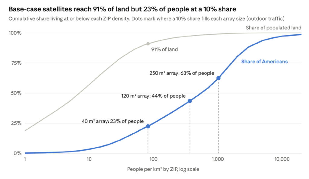
The 82 figure is a model output. If outdoor traffic is 30% rather than 40%, the threshold rises to about 109 people per km². At 60%, it falls to about 55. If phone usage doubles, it falls to roughly 41 and the share of Americans below the threshold drops to about 14%.
Beam width may move the result in the same direction. The formula I use predicts a beam about 27 km wide for today’s direct-to-cell satellites, while Ookla has measured beams from 38 to 88 km. If the next generation misses the theoretical beam width by a similar amount, capacity per km² is roughly halved. The 82-person line moves toward 40.
A larger antenna moves the line in the opposite direction. A 120 m² array raises modeled capacity to about 1.5 Mbps per km² and supports a 10% share at roughly 368 people per km². A 250 m² array reaches about 4.2 Mbps per km² and pushes the threshold just above 1,000. Even that is small beside a suburban terrestrial grid, which carries about 770 Mbps per km² in the comparison. The satellite can cover a lot of land cheaply. Dense capacity remains a different job.
The architecture changes quickly once the satellite reaches that density limit. Covering ZIP codes between 100 and 1,500 people per km² with terrestrial nodes of about 150 m radius takes roughly 17 nodes per km² after allowing for overlap. Across that band, the model needs about 8.1 million nodes. That is one host for roughly every eight households.
SpaceX does not have that suburban host footprint today. New Street estimates about 2.7 million US Starlink subscribers and more than 85% are rural. That leaves roughly 0.4 million dishes in the density band where the small cells are needed. The national build would require about 20 times as many hosts there.
Each host also needs power and backhaul. Using Starlink itself for the backhaul creates another capacity problem. A Starlink household can generate about 3.5 to 7.4 Mbps in the busy hour. At the host density required for the mobile nodes, that adds roughly 60 to 126 Mbps per km² before the mobile traffic is counted. Estimates for Starlink’s Ku and Ka capacity pool run from about 4 to 55 Mbps per km², and the broadband service already applies congestion charges in sold-out areas.
The reported talks with Charter fit this shape of problem. Charter already owns powered locations connected by cable or fiber. Its strand-mounted CBRS radios cost about $2,500 each and use the cable plant for power and backhaul. A suburban Starlink Mobile build becomes much easier if those locations come from a cable operator instead of millions of new Starlink hosts.
Helium offers a smaller example of the operating problem. It deployed about 4,000 consumer-hosted CBRS radios. They carried only around 2% of its data and generated a large share of support work before Helium shut the program down in 2025 and moved toward venue Wi-Fi. SpaceX would use licensed spectrum and professional outdoor mounts, so the radio design is different. The host problem remains. Thousands of inexpensive radios become a field operation once they sit on property owned by other people.
Dense cities force the network farther in that direction. ZIP codes above 1,500 people per km² hold about 93 million people on only 0.5% of populated land. Their average density is about 2,763 people per km². The base satellite case supports about eight mobile subscribers per km².
I model those areas with about 27,000 colocated macro sites at 1.2 km spacing. With 45 MHz of downlink, each site carries about 340 Mbps and supports a 10% share outside the densest part of the market. With 25 MHz, the figure falls to about 190 Mbps and densification arrives sooner. Incumbents typically operate around 300 MHz of sub-6 GHz spectrum per site. SpaceX would need roughly seven times their site density in the busiest cores to match capacity at the same market share.
This spectrum has already been through three attempts to pair satellite coverage with a terrestrial network. ICO, later DBSD, and TerreStar each launched a satellite and held rights to add terrestrial service in the 2 GHz band. Neither built the terrestrial network and both entered Chapter 11. DISH bought the assets in 2012 for about $2.86 billion. It later built roughly 24,000 sites covering 75% of Americans for about $7.7 billion. Fewer than 1 million customers were on its own-network postpaid plans when the radios went to AT&T in 2025.
SpaceX has advantages those companies did not have. Ordinary phones can now use 3GPP non-terrestrial networks. Low Earth orbit shrinks the beams dramatically. SpaceX owns its launch system and already has a global broadband business. None of those advantages removes the relationship between population density and local capacity. Once enough people share the same square kilometre, SpaceX has to add radios, sites and backhaul close to them.
The satellite fleet introduces a second economic dependency. I use 15,000 satellites at about $4 million each to build and launch, a 5.5-year life, an 8% cost of capital and $1.5 billion a year for the ground segment. That produces an annual fleet cost of about $15.4 billion, with a range of roughly $8 billion to $26 billion. A 5.5-year life also implies about 2,700 replacement satellites and around 55 Starship flights each year.
The US business does not have to pay for all of that fleet. A satellite keeps moving after it leaves the United States. The floor in the model assigns 4% of fleet cost to the US, roughly the share of orbit time spent in range of the lower 48. A central case uses 20%. A US-only fleet sized for one beam layer over the lower 48 would need about 6,800 satellites and carry roughly 45% of the global fleet cost.
That allocation changes the national mobile economics. At a 10% share, about 34 million lines, the modeled hybrid network costs about $37 per line per month if the US carries 4% of the fleet bill. It rises to $43 at a 20% allocation and $53 for the US-only case. T-Mobile collected about $42 per customer per month in service revenue in the comparison. Incumbent network capex and operations work out to roughly $16 per customer at that revenue level.
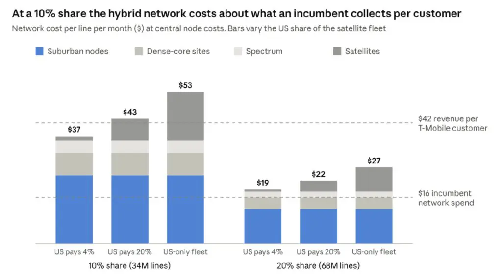
A 20% SpaceX share improves the unit economics because the same infrastructure serves more customers. The central case falls to about $22 per line. Getting there requires roughly 68 million US mobile customers. The cost curve requires SpaceX to win a very large share in the markets where the terrestrial build is most demanding.
The rural case asks much less of the ground network. At 17 million lines in ZIP codes below 100 people per km², network cost is about $16 per line per month if the US carries 4% of the satellite fleet. It rises to $28 at a 20% allocation and about $47 if the US effectively funds its own fleet. The rural business improves as carriers outside the United States pay for the same satellites while they pass over their markets.
Stankey’s cost argument is strongest where population density forces SpaceX onto the ground. In the base case, that starts around 82 people per km². Below that line sits 91% of populated US land. Above it sit 77% of Americans. A single national market-share number hides that split.
V2 Mobile will move that line. A 40 m² array puts the 10% share threshold near 82 people per km². A 120 m² array moves it to about 368. A 250 m² array takes it just above 1,000. Measured beam width will show whether those gains survive in the real network. New carrier contracts outside the US will show how much of the fleet American customers have to fund.
The first V2 Mobile number I will look for is busy-hour capacity per square kilometre. Once that is measured, the business case gets much easier to test. It will show how much of the country can be served from space before the cost of hosts and terrestrial sites begins to dominate each mobile line.